Observatoire de l'artificialisation des sols (données…
Visualization
Published on December 14, 2023 by Frogéo
This is a degraded experience of data.gouv.fr. Please enable JavaScript and use an up to date browser.
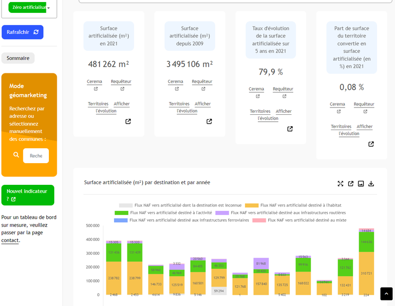
Données du portail national de l'artificialisation https://artificialisation.developpement-durable.gouv.fr.
Cette donnée est diffusée à une maille communale, avec un pas de temps annuel, pour la période 2009-2021 (du 1er janvier 2009 au 1er janvier 2021).
En outre, les données sont accessibles via un tableau de bord et une cartographie dynamique
La méthodologie complète, ainsi que les définitions considérées et les limites du traitement sont disponible sur le portail national : https://artificialisation.developpement-durable.gouv.fr
March 6, 2023
Licence Ouverte / Open Licence version 2.0
Data description filled
Files documented
License filled
Update frequency not followed
File formats are open
Temporal coverage filled
Spatial coverage filled
All files are available
Update frequency not followed
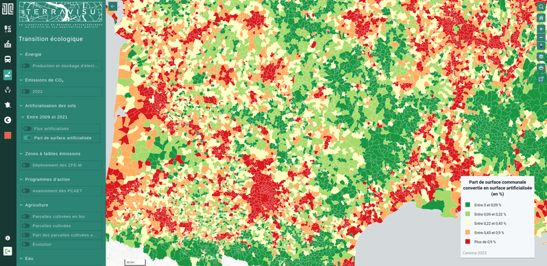
A map provided by the portal of soil artificialisation allows you to view local land consumption data.
Visualization
Published on December 14, 2023 by Frogéo
Application
Published on June 23, 2023 by Makina Corpus
Application
Published on June 14, 2022 by Territoire Circulaire

There are no discussions for this dataset yet.
There are no community resources for this dataset yet.
6405e3f2181d0f673cac60d7
March 6, 2023
Annual
2009/01/01 to 2021/01/01
March 6, 2023
France
French town
[{'id': 'https://artificialisation.developpement-durable.gouv.fr/cartographie-artificialisation', 'score': 50, 'source': 'edito', 'messages': {'en': {'title': 'Are you seeking to get a better understanding of soil artificialisation in France?', 'message': 'A map provided by the portal of soil artificialisation allows you to view local land consumption data.', 'button': 'View the map'}, 'fr': {'title': 'Vous souhaitez mieux comprendre l’artificialisation des sols en France\xa0?', 'message': 'Une carte proposée par le portail de l’artificialisation des sols vous permet de visualiser les données communales de consommation d’espaces.', 'button': 'Consulter la carte'}}}]
['edito']
2.7k
467
3
3