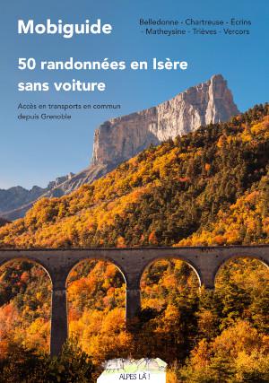
Une carte précise et open source pour des randonnées…
Paper
Published on October 13, 2022 by Alpes Là
The terms of use for data.gouv.fr have changed. We invite you to review them.
This is a degraded experience of data.gouv.fr. Please enable JavaScript and use an up to date browser.
Cette cartographie de l'occupation du sol est produite par classification automatique de séries temporelles d'images optiques Sentinel-2 par l'UMR CESBIO dans le cadre du CES OSO du pôle Theia.
This dataset has been published on the initiative and under the responsibility of
Vincent Thierion
Published on October 23, 2018 and updated on January 26, 2022
January 26, 2022
Open Data Commons Attribution License
Data description empty
Files documentation missing
License filled
Update frequency not followed
File formats are closed
Temporal coverage filled
Spatial coverage filled
Some files are unavailable
Data description empty
Files documentation missing
Update frequency not followed
File formats are closed
Some files are unavailable
There are no files for this dataset yet.
Paper
Published on October 13, 2022 by Alpes Là
There are no discussions for this dataset yet.
There are no community resources for this dataset yet.
5bcf4669634f412da3188cfe
October 23, 2018
Annual
2017
January 26, 2022
France
Country
71
0
1
0