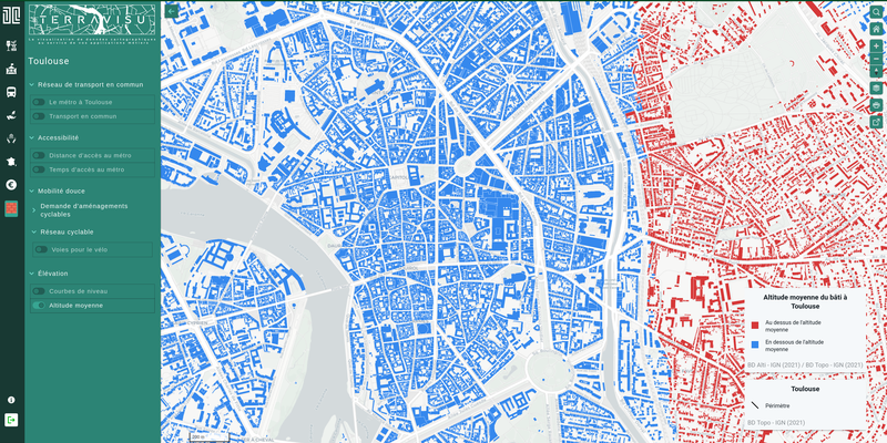
TerraVisu - Altitude moyenne du bâti à Toulouse
Application
Published on June 22, 2023 by Makina Corpus
The terms of use for data.gouv.fr have changed. We invite you to review them.
This is a degraded experience of data.gouv.fr. Please enable JavaScript and use an up to date browser.
La BD ALTI® apporte une 3ème dimension pour représenter et analyser le territoire à moyenne échelle. Historiquement calculée entre 1987 et 2001, la BD ALTI® était issue de la numérisation de cartes et de restitution photogrammétrique. Aujourd’hui elle est calculée a partir des données RGE ALTI®.
This dataset come from an external portal. View the original source.
December 7, 2022
Licence Ouverte / Open Licence version 2.0
Data description filled
Files documentation missing
License filled
Update frequency not set
File formats are open
Temporal coverage not set
Spatial coverage not set
All files are available
Files documentation missing
Update frequency not set
Temporal coverage not set
Spatial coverage not set
Application
Published on June 22, 2023 by Makina Corpus
There are no discussions for this dataset yet.
There are no community resources for this dataset yet.
63912b89835cce89aca1833f
December 7, 2022
December 7, 2022
None
None
None
None
CKAN
2022-12-07 00:00:00
2022-12-07 00:00:00
5ea132a8706a5afa004a5911
e5d898a9-7a49-4b37-989a-0251380db660
ckan.openig.org
2024-04-29 00:20:58.681000
https://ckan.openig.org/dataset/bd-alti
bd-alti
2k
903
1
0