Polices municipales de France 2012
Description
Jeux établis à partir des données 2012 fournies par Etalab pour La Gazette des communes. Géolocalisation par kml correspondant au contour des communes (pour les quelques grosses villes concernées, agrégation des arrondissements).
Author
This dataset has been published on the initiative and under the responsibility of
Sabine Blanc & Julien Kirch
Published on January 31, 2014 and updated on August 13, 2015
Latest update
August 21, 2014
License
Licence Ouverte / Open Licence
Metadata quality:
Data description filled
Files documented
License filled
Update frequency not followed
File formats are open
Temporal coverage filled
Spatial coverage filled
All files are available
Metadata quality
Update frequency not followed
2 Reuses
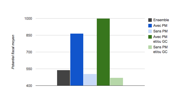
Police municipale et communes riches : une certitude…
News Article
Published on August 21, 2014 by Sabine Blanc & Julien Kirch
There are no discussions for this dataset yet.
There are no community resources for this dataset yet.
Information
Tags
License
ID
53699d02a3a729239d205b10
Temporality
Creation
January 31, 2014
Frequency
Annual
Temporal coverage
2012
Latest update
August 21, 2014
Spatial coverage
Territorial coverage
France
Territorial coverage granularity
French town
Actions
Embed
Extras
datagouv_ckan_id
19933529-963a-406b-9fd5-a6090ef8e654
datagouv_ckan_last_sync
2014-09-16 09:54:33.572000
Statistics for the year
Views
761
Downloads
694
Reuses of this dataset
2
Followers
0